Saturday, March 30, 2013

Grand Canyon :: Indian Gardens to Plateau Point

This is the third installment, before continuing you might want to read the first and second parts of the story! For whatever reason, most likely just plain tired, I didn't get any pictures of our campsite. Like all of the sites at Indian Gardens it had a picnic table with a shelter over it along with metal boxes in which to store your food and toiletries (the odors will draw the critters). After a brief rest we ate our lunch of pita bread sandwiches, protein bars, and trail mix. For some reason it tasted quite good!

Then it was off to our second destination of the day – Plateau Point, which lies 1.5 miles north over a relatively easy trail. The trail to Plateau Point can be seen in the second photo of the second post in this series.

As we were coming off the last switchback and down into the canyon at Indian Gardens we had noticed a change. More trees, brighter green, and glorious Red Bud trees in full bloom! Just beyond the campground, alongside the stream, there was a grove of Red Buds. Their flowers contrasted brightly against the green of the surrounding trees and the grass growing beneath their branches.


And the little cactus plants literally covered the ground in some spots. And they were nearly ready to burst forth into bloom! On the way out to Plateau Point, we saw just one cactus in bloom with gorgeous deep red flowers, but it was too far off the trail. However, on the way back, Fred spotted another blooming cactus, just a few feet away. I just had to stop and get a few pictures of it. Amazing color. And it wouldn't be long before the desert floor was carpeted with their color. It had to have been an incredible sight.


The view of the Colorado River from Plateau Point, looking east.

Looking west.

We spent several hours at Plateau Point. Much of the time we were alone and it was so peaceful and quiet. People would come and go, make noisy chit-chat, then leave us. For a while we watched a group of six Condors riding the air thermals until they disappeared into the distance. You could occasionally hear the water tumbling over the rapids far below. Ravens soared and swallows flitted over and around us. Sitting on the rocks, on the edge, yet in the middle of the Canyon is indescribable. As the sun lowered in the sky, the air took on a chill, and we reluctantly left Plateau Point.

We thought about staying and watching the sunset, but we didn't have any lights with us. Instead, we went back, got our lights, then walked to a point that provided a decent view. We knew we wouldn't be able to actually see the sun drop below the horizon but thought perhaps it's waning rays would add some color to the Canyon. It wasn't spectacular though it was quite nice. A fitting end to an incredible day. One that started out a little “iffy” but turned out great. We really couldn't have asked for a better day to make the trek into the Canyon. Quite memorable.

Friday, March 29, 2013

More of Day 3


After the picnic on day 3 we traveled on north to Kalaloch Beach (my guide informed me it was pronounced Clay-lock) - from the mossy trees to the open coast. I am finding out that the trip up the Washington coast has some very unique country and is very interesting.
It was the first time I had seen the ocean in about 4 years. I was thrilled. We took the short hike down to the waters edge, sat on an old log, pulled off our shoes and rolled up our jeans. I couldn't wait to wade into the ocean. But was I surprised! Now I understood why Jan said we wouldn't need our swim suits at the beech. That water was way too cold to get more than our toes into it. There were people who had on swim suits or shorts and were getting wet. Jan said they were probably local people who did it frequently and were used to how cold the water was.
But regardless of the chill (and remember it was August) we waded, made tracks in the wet sand, and looked for sea shells. The tide was coming in and we didn't find anything but broken shells. I took lots of photos of the waves coming into the shore and of the sun just starting to think about sinking toward the west, as well as a few brave kids playing in the surf and building sand castles.
Interestingly there were big, tall trees that came almost down to the shore, leaving only a few feet of sand that varied from 3 or 4 feet up to about 50 feet for the beech area. I was intrigued by this as most of my visits to the beach had been in Florida and southern California where there were usually houses down to the shore or beach's. I had always seen photos of the trees and cliffs by the shore and always wanted to see it. Now I was. There were lots of logs laying everywhere. Great big logs that had once been great big trees. My guide said that sometimes trees fall off of cliffs and get into to the ocean. Other times the logs are lost from logging operations near the shore, or from barges that carry logs on them or they might have been sunk in the ocean for hundreds of years. With the changing of tides and storms they are unburied and wash ashore. Every year a few people are killed when they are playing on the beech and don't notice that there is a log coming in to shore. They are very heavy but the waves and water can throw them tremendous distances making dangerous missiles out of them.

Wednesday, March 27, 2013

Success, failures and a happy thrashing to all!

Since my return to rock climbing this past summer, Laura and I have been very busy doing crag work and climbing as much as possible. My shoulder injury from last winters rail antics at 7 Springs seemed to take forever to heal into climbable shape. Starting slow and climbing mostly on 5.11 and under seemed to be working at improving my weak shoulder. After only a short time back and feeling a better I upped the stakes and decided to tryPinch Me I'm Dreaming a 5.12+ mixed gear line at The Knobs in Dunbar, PA. The climb went pretty well, except that I aggravated my shoulder during the ascent. Once again I eased back down to vast amounts of sub 5.10's and easing into 11's for the past several months trying to heal it more. I've since recovered enough and managed to climb a few easy 12's without more injury and am feeling OK, but definitely not 100%. I really want to get back into projecting routes and being able to push harder, but I've been nervous about further injury and destroying myself for ice season. Yesterday Laura and I decided to ride into River's End Crag and climb there for a few hours. We climbed several climbs and I decided it was time to see how healed I was. I decided to drop a rope on Sludge Factory a 5.12+ that I've yet to red point. I figured the top rope was best that way I could safely test my shoulders thresholds without over doing it due to red point determination. I've only tried the route a few days since equipping it back in late . Its seen a couple of ascents that I know of and is a solid route for the grade. To date the best I've done is one hang it. There are two very distinct cruxes on this route. One is making it past the first bolt, the second is surmounting the large overhang at the top. In past efforts the top crux has been my Kryptonite. I'm usually so pumped that hanging in for the last clip is not within my abilities and off flying I usually go waiting to hit the ledge below. Yesterday was just the opposite. The bottom crux rocked my world in every conceivable fashion and the upper went without a hitch despite needing a good brushing. I hope this is the sign of better things to come. I've been waiting patiently trying not to hurt myself, but I really miss working near my limits. I've been recently given the pleasure of watching people on our new routes and have throughly enjoyed seeing both success and failure. Not failure because I'm glad they didn't succeed, but glad in a sense that I remembered how much fun failing can be. Failing means you get to have more days perfecting sections that are "tricky" for you, which in turn makes you a more fluid climber. I haven't met a climber that doesn't like success. The more effort, the sweeter the success. Even after the greatest successes I've found that the "send high" is only a short lived moment of glory that is quickly eclipsed by the next line looking to smack you down. Yesterday was just that for me, the fun part... working the line... getting beat by it and getting to come back and try again another day. Failing just means another day of climbing!


Equipping Sludge Factory in

One of the amazing events I recently witnessed was Laura having a great break through this past week. After being dejected by the crux start ofDeliverance5.11+ at Bruner Run on many attempts, she worked out an inspiring sequence that proves that short folks CAN do this line. Using obscure stemming and showing extreme flexibility, she managed to get a clean send. It was quite funny how convinced she was that it was "impossible for her". She declared that it was a line that she'd never get due to the long reach. Only by pure determination and serious effort was she rewarded with the realization that she could send harder lines... Her display of cranking convinced me that I needed to get back to trying harder despite my shoulder. To put the plan in motion, I'm declaring war on Sludge Factory after a couple rest days. Then its on with Devil's Doorway a project route thatI put anchors on Monday. Its a hard line that repeatedly spit me off years ago when I was a stronger climber. Will I ever send it? Hopefully...or not. Getting to try it once again without injury will be reward enough for me! Happy Climbing


On another note be sure to check out the Ohiopyle climbing guide I've put together in blog form. You can find it on the menu at the top of my page! I'm also working on updating my old Breakneck information and making it available. If you find these useful, drop me a comment. I'd be happy to create guides for other SWPA crags if y'all would like them.

The 44th Regiment at Shiloh :: The Photo

This is the second of two photographs from the display at the visitor center at Shiloh National Battlefield.

The caption for this photo reads “The men of the 44th Indiana Infantry Regiment display their arms and accoutrements before the battle.” Written in the lower right corner is “Comy H 44 Ind”

The close-ups below begin from the left hand side of the above photograph. There is some overlap in the close-ups so some men will appear on more than one of the pictures.


Ice Arch Sunrise


This winter has been quite productive when it comes to having interesting ice formations to photograph, much more so than last winter. December and January had plenty of very cold days which meant that there was quite a bit of ice both along the shore and floating around in various places on Lake Superior. Near the end of January we had a wind storm that came up and blew a lot of this ice onto the Minnesota shoreline of the lake. Just north of Grand Marais was one area in particular where the ice had been jammed into many fascinating forms along the beaches. The wave action not only resulted in the packing of the ice along the shoreline, but also contributed to the hollowing out of the ice from underneath in several places. Several ice arches were formed as the waves continued to work at the ice from below.
The arch shown in this image was the most photogenic arch that I found. On the morning I made this image I was photographing the shoreline with my friend Paul. It was a very calm morning which was a stark contrast to the previous days which had made all these ice formations possible. Paul and I set up our tripods and started making images of the arch. We had only taken about 5 or 6 images each when we heard a cracking sound. Both of us were in the process of moving our tripods to set up a different shot when we heard the cracking. We both looked up just as the arch collapsed into the water. Needless to say, this scene was a lot less interesting to photograph after the arch fell. Thankfully we each got a few images before it was gone! This image was made at 8:03 AM using my Canon EF 17-40mm lens. Shutter speed was 1/15, aperture f16, ISO 100.

Monday, March 25, 2013

Hidden gems ... check them out

Whilst I am busying myself returning from Spain, via France (and maybe a couple of other destinations en-route) I thought I would share with you the content of an email that I received earlier today.


If you are planning your travels in the coming months I urge you to check out this link which collates the entries to a travel writing competition entitled 'Hidden Gems'.


I have often shared my visits to the Lake District in the UK via my travel blogs. The entries to the competition show that others also feel this is an area of the world with some hidden gems. Then there are lots of other places that feature...


Do check out the Colombia entry, and if you want to read the full unedited version of the experience at this 'Hidden Gem' then check out my original entries starting here.


I'd love to know what you think and, if you have been there yourself did you have a similar experience?

Bull Snake

With all the moving of dirt with the tractor a snake was discovered wondering around wondering what was happening to his home. We assumed he or she was a bull snake as it didn't have any rattles on it's tail but it could have been some other kind of snake as I am not very versed on snake species. Anyway we encouraged it to slitter up in under a wild four-a-clock clump and it has not been seen since. I don't bother them if they as they eat lots of mice and rats of which we have enough for several snakes like this one.


Beachcombing #4


Padre Island National Seashore
Corpus Christi, Texas
February 17, ..

Achoo.

I brought home something unintended from the craft show: a bad cold.

I usually swear by Cold-Eeze. They are magic! For me, they can fend off colds altogether, but you have to use them early.

It hadn't rained in Stone Mountain lately, and I naively assumed that the reason I had a stuffy nose was due to all the dust I'd inhaled over the course of four days spent outdoors.

Until my throat started hurting and I got a fever. I really should have known better, especially considering that the same thing happened to me last year.

So since I feel too crummy to go out and take pictures, here's one from a few weeks ago, of some of the eggs from our chickens. I love it when we get speckled ones! Yesterday there was a decidedly beige one too.


I haven't slept well in several nights, but I did have a good dream... I dreamed that a lady came to the craft show and bought ALL the soap. I woke up and thought how great that would be. Then I fell back asleep and had the same dream again, except this time it was Stephen Duffy who bought all the soap. Cool.

Hubby has the same cold, only without the fever. As far as I know, he hasn't dreamed about any pop stars though.

Evacuation and Damage

The Park remains closed until further notice. For updated information, call 360 569 2211 ext 9.

The onslaught of rain continued throughout the night. The Paradise telemetry recorded another 7 inches, bringing the total to 18 inches of precip over the course of the storm... and it's still raining!

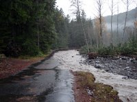
Aside from the rage of the Nisqually River, Longmire is a relatively quiet place. The NPS has closed its offices, and only essential personnel are allowed in through a backroad (which is largely washed out and requires shuttles). See image above, taken near the Eagle Peak Trailhead...

The flooding has seriously damaged or threatened many of the roads (and even a few of the facilities) in the park. This image was also taken from the Longmire backroad below the Community Building. You can see where the road once existed.

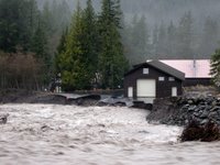
Longmire is isolated by washouts and mudflows, so it feels like a safe little island. Well, "safe" unless you're in the Emergency Operations Center (pictured left) which is being undermined by the Nisqually River... Oh, and some of the electrical and water systems are also damaged, but most of the facilities will probably survive the storm.


I'll provide updates when possible. If you plan on visiting this side of the park anytime soon, consider that it's going to take a few days to repair the main road between the Nisqually Entrance and Longmire. I hear that it's completely washed out near Sunshine Point Campground. And speaking of that campground, it's GONE.

Wednesday, March 20, 2013

Verdant Cascade


Verdant Cascade, originally uploaded by ParsecTraveller.

I came across this small waterfall while hiking in the Las Trampas Regional Wilderness. I was amazed at how green and vivid the boulders were.

All of Las Trampas is filled with interesting sights and habitats. There are hot, dusty, chaparral-covered ridges, dark, fern-filled forests, and wildflower-dotted grasslands.

These waterfalls, however, are the park's crown jewels. Hidden away in the forest, they are visited by few and known by even fewer.

Saturday, March 16, 2013

A few short walks down under


Some short walks in New Zealand


Health warning - this post was written later than the date above!


21 November
Trig Track and Wilkinson Track Kapiti Island


The enchanted islandis a nature reserve and can only be accessed with a permit. It has been forcibly cleared of predators such as rats, possum and stoats, to restore native fauna and flora. There are various walks and activities at the two places where the public is allowed.

We had to take a boat from Paraparaumu on the west coast of North Island.


We landed at Rangatira, halfway along the eastern shore of Kapiti Island.


After our introductory pep talk about the wildlife and conservation, we decided to take the Trig Track up towards the highest point on the island, Tuteremoana (521 m)


Trig Track


  • 2km steady uphill climb, considerably steeper than Wilkinson Track, with narrow, uneven sections.


  • Requires a medium to high level of fitness.


It was indeed steep, and hard work.


Looking back down the Trig Track towards Harry, and our guide, who showed us several native birds

We paused at a bird feeding station, which is essential for the hihi, or stitchbirds. Some of the bigger birds can out-compete them for food. From there it was another few minutes to the junction with the Wilkinson Track, a twenty minute walk to the summit lookout. Lunch in hot sunshine.


Tuteremoana summit lookout


View from the summit lookout

We took the Wilkinson Track downhill - a gentler choice for the descent. It wasn't wet.


Wilkinson Track


  • Well-formed 3.8km track with a steady uphill climb.


  • Gentler gradient than theTrig Track.


  • You’ll pass a picnic area and hihi feeding station a third of the way up.


  • Sections of this track can be slippery in wet weather. Take care and wear suitable footwear.


Some historical information:


Historic sites
At the start of the Wilkinson and Trig Tracks is a historic whare, the oldest building on the island and the oldestassociated with nature conservation in the country. It is thought to originate from the early 1860s when it was built as the homestead for the McLean family who farmed the island at the time. It was later hometo caretakers on theisland including Richard Henry, the world’s first state-sponsored conservation officer.It is nowa base for scientists, trappers, students and numerous dignitaries and visitors.
Nearthe landing area you’ll find whaling trypots—artefacts from the island’s whaling history.

The three shaded sections are from the information on the NZ Department of Conservation website about Kapiti Island.


22 November
North End of Kapiti Island - Okupe Loop Walk


Okupe Loop Walk

  • 4.8 km/1.5 h return. Winds up a fairly gentle ridge through regenerating bush leading along the ridge top to the north-western lookout.

  • The track is accessed from the visitor shelter by following the track around the edge of the Okupe Lagoon.

  • Requires a low to medium level of fitness.

  • Suitable for all terrain prams around entire length.


We walked along this before leaving Kapiti Island later on the second day, after our overnight stay, and kiwi walk.


The Okupe Loop track was gentle, compared to the Trig Track.


Near the Northwestern Lookout


great view


26 November
Pelorus Bridge - Circle Walk


There's a campsite and a café at Pelorus Bridge Sceninc Reserve, and the café sells leaflets about several walking tracks. We arrive quite late one afternoon, and decide to try the short Circle Walk.


We have to cross the road bridge before starting on the track.


From here it's a pleasant, not too strenuous wander across a footbridge over the Rai, and then through woodland with views of the Pelorus river.


Afterwards we take another short track to the rocks and a swimming hole.


You can see the road bridge clearly - one lane only!


28 Nov


A couple of miles along the Queen Charlotte Track from the start at Anakiwa


The Queen Charlotte Walkway is a long distance path, and you need to buy a permit to walk any distance. Much of it is well away from road access, and some people arrange to be picked up by boat at strategic points. The alternative is to arrange accommodation along the way. We met some people who had walked it, when we took at ride on the Pelorus Mail Boat from Havelock, and they said it was not difficult, provided you were prepared and reasonably fit.

We didn't have time to organise a long walk, but did tackle a very short section at the beginning - no permit needed for this bit. It made a pleasant evening stroll.

Our route


The path begins by the water at Anakiwa, and climbs up through woodland, then down towards Davies Bay. We hung around the bay for a while watching a wader, and also a New Zealand kingfisher - bigger than ours and nowhere near as shy.


spot the birdie


The hill shapes are typical of New Zealand.


December 1 - Cullen point, near Havelock.


This was a very short walk - about half an hour or so, up to the top of Cullen Point, with a view over the Pelorus sound.